
Overview
MapGO is a browser-based geospatial workspace that brings a range of location intelligence tools into a single, accessible interface. The platform targets professionals who need to measure distances, understand administrative boundaries, and convert spatial data without installing heavy desktop GIS software. It addresses a common pain point: traditional GIS tools like QGIS or ArcGIS are powerful but often require significant setup, a steep learning curve, and are aimed primarily at specialists. MapGO instead focuses on quick, interactive analysis directly in the browser, making geospatial operations approachable for developers, data analysts, urban planners, and logistics coordinators.
The workspace is built around a high-resolution dataset covering 250+ countries and territories, with coastline and boundary shapefiles that power core measurements. Users can drop a coordinate and instantly retrieve its administrative hierarchy, distance to the nearest border or coastline, and even convert GPS coordinates between formats. In addition, the platform supports drawing and measuring on the map, including distance, area, radius, and bearing calculations, all of which update live as the user clicks. For data-heavy workflows, MapGO offers bulk CSV processing and file conversion between common GIS formats such as GeoJSON, KML, GPX, Shapefile, and CSV. A developer API is also available on RapidAPI, enabling teams to integrate geospatial intelligence directly into their applications.
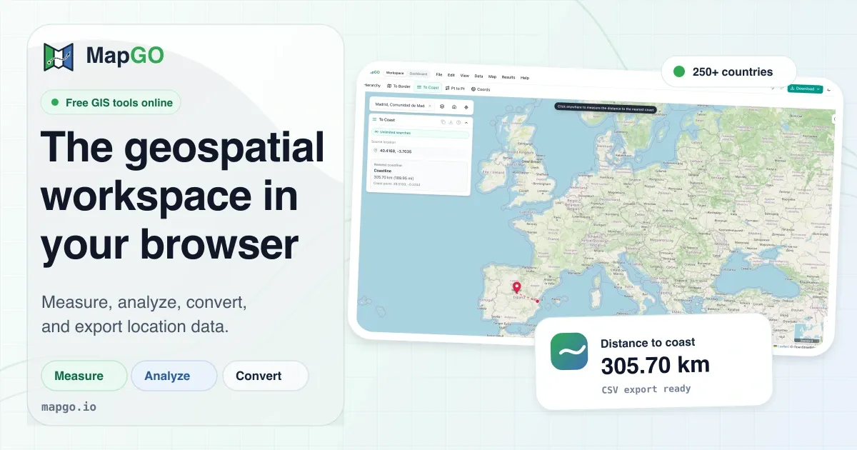
The user experience is deliberately minimal and intuitive. The landing page showcases a screenshot of the workspace with an interactive map, and the tools are organized into three main categories: Analyze, Measure & Draw, and Convert & Upload. This structure makes it easy to find the right function quickly. The platform is designed to feel like a web application rather than a traditional GIS suite, and the absence of a learning curve is a significant advantage. MapGO is positioned as a lightweight alternative to desktop GIS, and its free tier makes it easy to evaluate. The tool is particularly appealing for small to medium-sized teams that need fast answers to spatial questions without the overhead of data preparation. While it does not attempt to replace full-featured GIS software for complex cartographic production, it excels at interactive exploration and ad-hoc measurement tasks. The interactive workspace is the central hub where all of these capabilities come together, and it requires no installation or configuration.
Key Features
Location Hierarchy: For any given coordinate, MapGO returns the corresponding country, region, and district. This feature leverages the platform's comprehensive administrative boundaries dataset, which includes sub-regions down to the district level. The hierarchy appears instantly, making it useful for reverse geocoding and understanding the political or administrative context of a location. It is particularly helpful for applications that need to display local government information or route data through administrative workflows.
Distance to Border and Coastline: The platform calculates the shortest distance from a point to the nearest national or regional boundary, as well as to the nearest coastline. These measurements are essential for compliance checks, risk assessments, and decision-making in sectors like shipping, aviation, and real estate. The underlying dataset ensures high precision, even in complex coastal geographies. In the browser, the user can see the result immediately after clicking a location, and the value is displayed clearly on the map interface.
Point-to-Point Distance: Users can measure the great-circle distance between two coordinates. This is a straightforward yet frequently needed function for logistics, travel planning, and route analysis. The result is displayed clearly, and the interaction is seamless. Users can click on the map to set the first point, then move the cursor to see a live preview before clicking the second point to finalize the measurement.
Measurement Tools: Beyond simple point-to-point distances, MapGO provides tools to measure area, radius, and bearing. Users can draw polygons directly on the map and read the area instantly, create a circle from a center point to understand radius, and calculate the compass bearing between two locations. These tools update live as the user manipulates the map, offering immediate feedback. This set of tools is particularly useful for site selection, property analysis, and navigation planning.
Buffer and Draw: The platform includes the ability to create buffer zones around points or areas, as well as to draw custom annotations. This is particularly valuable for visualizing catchment areas, safety zones, or service coverage. The drawn elements can be layered on top of the map, aiding in spatial analysis and presentation. Users can customize the size of the buffer and the style of annotations, making it a versatile presentation aid.
File Conversion and Bulk CSV Processing: MapGO supports file conversion among GeoJSON, KML, GPX, Shapefile, and CSV formats. Users can upload a GeoJSON file containing countries, regions, or other features and render it on the map. For large datasets, the bulk CSV upload feature allows processing thousands of latitude/longitude rows in a single operation, enriching each point with hierarchy and distance data. This is a major time-saver for analysts who work with data exports from spreadsheets or databases.
Developer API: The platform offers a REST API via RapidAPI, enabling developers to call endpoints for full location responses, including hierarchy, border distance, and coastline distance. This API is designed to be simple and fast, with documentation and a generous free tier, making it accessible for prototyping and production use. The API example on the landing page shows a simple JavaScript fetch call to retrieve a full response for coordinates in London, returning the hierarchy, border distance, and coastline distance in JSON format. This makes integration straightforward for any modern web application.
How It Works
Getting started with MapGO is straightforward. The homepage presents two primary entry points: "Open Workspace" and "Create Free Account". Users can also access the workspace without signing up, though they will be limited to 5 free lookups per day. Creating a free account raises this limit to 10 lookups per day and unlocks additional features. Once in the workspace, users are presented with an interactive map and a set of tools that can be activated from the sidebar.
The main workspace is split into sections for analysis, measurement, and conversion. To analyze a single coordinate, the user simply clicks on the map or enters coordinates directly. The workspace immediately displays the location hierarchy, distance to border, and distance to coast. For point-to-point distance, the user clicks two locations, and the great-circle distance appears on the screen. The measurement tools work in a similar fashion: selecting the distance tool and clicking points draws a line with the measurement shown live. Area and radius tools follow the same intuitive pattern. A user can draw a polygon and see the area calculated in real time as they add vertices.
For file conversion and bulk processing, the workspace includes a dedicated section where users can upload a file or paste coordinates. The platform processes the data and returns enriched results, which can be downloaded in the desired format. The file conversion tools are also available separately, focusing on format translation without the analysis components. The workflow is designed to minimize friction, and since everything runs in the browser, there is no installation or special hardware requirement. The entire experience is responsive and tailored for desktop use, with a clean interface that prioritizes the map and the selected tool's parameters. Users can switch between tools seamlessly, and the map retains its state, allowing for multiple measurements to be taken in a single session.
Use Cases
Logistics and Supply Chain: A distribution manager needs to know the distance from a warehouse to the nearest border to estimate customs clearance times. By dropping the warehouse's coordinates into MapGO, the manager quickly obtains the border distance and can compare multiple sites. The point-to-point tool helps calculate transit distances between fulfillment centers, and the buffer tool can visualize service areas around each depot.
Real Estate and Property Analysis: A real estate analyst evaluates coastal properties by measuring their proximity to the coastline. With MapGO's distance-to-coast feature, the analyst can rank properties based on their distance to the shore, providing valuable data for pricing and investment decisions. The buffer tool can visualize a 300-meter radius around each property to assess flood risk, while the area tool measures the size of a plot from a map.
Disaster Management and Emergency Response: An emergency planner identifies vulnerable areas by analyzing distances to national borders and coastlines. MapGO's location hierarchy helps understand which administrative district a coordinate falls into, aiding in resource allocation. The area measurement tool supports the sizing of evacuation zones and operational areas. In a crisis, the fast, browser-based nature of MapGO allows field teams to get instant answers without specialized GIS support.
Developers Building Location-Aware Apps: A developer integrates MapGO's API into a civic engagement app to show users their local government district and representatives. Using the API, the developer sends coordinates and receives the full hierarchy in return, powering a personalized experience. The free tier allows ample testing during development, and the simple REST interface means it can be connected to a frontend in minutes. The API's response format is well-documented, reducing the need for custom parsing code.
Environmental Research: An ecologist studies the distribution of a species relative to protected areas. By uploading a CSV of observation points, the researcher gets distance-to-border and hierarchy data for each point, enabling analysis of how proximity to boundaries affects habitat use. Bulk processing saves time and provides consistent output. The file conversion capabilities also allow the researcher to export the enriched data in a format compatible with other analysis tools.
Pricing & Value
MapGO adopts a freemium model with a free tier that requires no credit card. Unregistered users receive 5 free lookups per day, while registered free accounts receive 10 lookups per day. This is a generous allowance for evaluation and light usage. The landing page does not display detailed paid pricing, but it directs users to a dedicated pricing page. For teams that need higher volume, the API offers its own free tier on RapidAPI, with paid plans scaling according to usage. Compared to traditional GIS licenses that can cost hundreds or thousands of dollars per user, MapGO's pricing is likely to be more accessible, particularly for small teams and individual analysts. The exact cost for premium features remains somewhat opaque from the landing page, and potential customers are encouraged to explore the pricing and plans directly. The free tier alone provides enough functionality to solve many real-world problems, making MapGO a low-risk tool to adopt. Additionally, the platform's browser-based nature reduces total cost of ownership, as there is no hardware upgrade or IT support required for installation.
Final Verdict
MapGO is a refreshing take on geospatial analysis, prioritizing ease of use and immediate accessibility. Its comprehensive set of tools, from distance measurements to file conversions, covers a wide range of use cases that previously required specialized desktop software. The browser-based approach means that users can start working within minutes, with no installation hassles. The inclusion of a developer API extends its utility beyond the interactive workspace, making it a versatile addition to a data stack.
However, there are trade-offs. The free tier's lookup limits may be restrictive for heavy users, and the lack of detailed pricing on the main site adds friction for those evaluating costs. Additionally, because it is browser-based, an internet connection is required, and users needing offline capabilities may find it lacking. For developers, data analysts, and business professionals who need quick spatial insights without substantial investment, MapGO is a strong choice. Those who require advanced cartography or intricate spatial analysis might still need a dedicated GIS platform. Overall, MapGO offers excellent value as an entry-level geospatial tool, and its free tier makes it worth trying for anyone with location-based questions.